Satellite Map of Big Ben Area
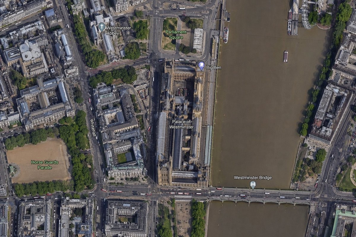
此提示词可生成一张以大本钟和威斯敏斯特宫为中心的逼真标注式卫星航拍地图,适用于地图对比、地理位置可视化及地理背景图像。
A high-resolution top-down satellite map view of central {argument name="city" default="London"}, focused tightly on the area around {argument name="landmark" default="Big Ben"} and the Palace of Westminster beside the River Thames. Show a realistic aerial orthographic perspective like a modern digital map or satellite layer, with detailed rooftops, streets, trees, shadows, and brownish river water. Place the long Palace of Westminster complex vertically near the center-right, directly along the west bank of the river, with Big Ben at the northeast corner of the palace near the river edge. A bridge labeled {argument name="bridge name" default="Westminster Bridge"} crosses horizontally near the bottom of the frame from left to right over the river. Include 6 visible map labels total: {argument name="label 1" default="Westminster Abbey"}, {argument name="label 2" default="Parliament Square"}, Big Ben, Palace of Westminster, Westminster Bridge, and Horse Guards Parade. Also show Whitehall as a labeled road running vertically on the left side of the palace area. Surrounding details should include Westminster Abbey in the upper left quadrant, Parliament Square above the palace, Horse Guards Parade as a large sandy rectangular ground in the lower left quadrant, dense city blocks and roads on the left half, the River Thames occupying the full right side, embankments on both sides, a few boats on the river, and tree-lined streets and parks. Use natural satellite-image colors, crisp cartographic label overlays, and the look of a zoomed-in online maps screenshot. 一张以 {argument name="city" default="伦敦"} 市中心为核心的高分辨率俯视卫星地图,紧密聚焦于 {argument name="landmark" default="大本钟"} 及泰晤士河畔威斯敏斯特宫周边区域。呈现出现代数字地图或卫星图层般的逼真航拍正射视角,包含详细的屋顶、街道、树木、阴影及棕褐色的河水。将长条形的威斯敏斯特宫建筑群垂直放置在画面中右侧,紧邻河流西岸,大本钟位于宫殿东北角靠近河岸的位置。一座标注为 {argument name="bridge name" default="威斯敏斯特桥"} 的桥梁在画面底部从左至右横跨河流。总共包含 6 个可见地图标签:{argument name="label 1" default="威斯敏斯特教堂"}、{argument name="label 2" default="议会广场"}、大本钟、威斯敏斯特宫、威斯敏斯特桥和骑兵卫队阅兵场。同时将白厅作为一条标注道路,垂直显示在宫殿区域左侧。周边细节应包括左上象限的威斯敏斯特教堂、宫殿上方的议会广场、左下象限作为大型沙色长方形场地的骑兵卫队阅兵场、左半部分密集的城市街区与道路、占据整个右侧的泰晤士河、两岸的堤岸、河上的少量船只以及绿树成荫的街道与公园。采用自然的卫星图像色彩、清晰的地图标注叠加层,呈现出放大后的在线地图截图效果。 중앙의 {argument name="city" default="런던"}의 고해상도 정면 위성 지도 뷰로, {argument name="landmark" default="빅벤"}과 템스 강가의 웨스트민스터 궁전 주변 지역에 밀접하게 초점을 맞추고 있습니다. 현대 디지털 지도 또는 위성 레이어와 같은 사실적인 항공 정사각형 관점을 보여주며, 상세한 지붕, 거리, 나무, 그림자 및 갈색 강 물을 포함합니다. 긴 웨스트민스터 궁전 복합체를 화면 중앙 오른쪽에 수직으로 배치하고, 강의 서쪽 기슭에 직접 위치시키며, 빅벤은 궁전의 북동쪽 모서리, 강 가장자리에 있습니다. {argument name="bridge name" default="웨스트민스터 다리"}라는 레이블이 붙은 다리가 화면 하단에서 왼쪽에서 오른쪽으로 강을 가로지릅니다. 총 6개의 가시적인 지도 레이블을 포함합니다: {argument name="label 1" default="웨스트민스터 사원"}, {argument name="label 2" default="국회의사당 광장"}, 빅벤, 웨스트민스터 궁전, 웨스트민스터 다리, 그리고 기병대 퍼레이드. 또한 궁전 지역의 왼쪽에 수직으로 달리는 레이블이 붙은 도로로 화이트홀을 보여줍니다. 주변 세부 사항에는 왼쪽 상단 사분면의 웨스트민스터 사원, 궁전 위의 국회의사당 광장, 왼쪽 하단 사분면의 큰 모래색 직사각형 땅으로서의 기병대 퍼레이드, 왼쪽 절반의 밀집된 도시 블록과 도로, 오른쪽 전체를 차지하는 템스 강, 양쪽의 제방, 강 위의 몇 개의 보트, 그리고 나무가 늘어선 거리와 공원이 포함됩니다. 자연적인 위성 이미지 색상, 선명한 지도 레이블 오버레이, 확대된 온라인 지도 스크린샷의 모습을 사용합니다.